Forest Walk

Forest Walk

WALK MORE – WORRY LESS

Morning walk in the Forest

Reset Apartments
Forest/Macadam road
Reset Apartments

EXTEND TO

Podkoren Village
Kranjska Gora, Slovenia

The village Kranjska Gora is surrounded by vast spruce forests, crisscrossed by numerous paths. Explore the forest glades, vast meadows, and pastures in the surroundings, with beautiful views of the Karavanke mountain range and the many peaks of the Julian Alps. Most of the paths away from the tourist attractions are rarely used by tourists, as few visitors are aware of the network of footpaths that cross the regional road, opposite our apartments.

“Kozolci” (hayracks) are specific to the Upper Sava Valley. Due to the very humid climate, they have been and continue to be used as a preparation for drying hay.

If you want to take a short walk, get some exercise, get some fresh air, or just run, you can do a circuit through the woods and surrounding meadows (map above). The paths and tracks are arranged and suitable also for short family walks and anyone who wants to enjoy nature and silence. And don’t worry – you won’t get lost, as all paths and tracks lead back to Kranjska Gora or the nearby village of Podkoren. You can also explore the trails with a mountain bike and if you want to have a picnic in nature, you will quickly find a suitable place here.

Directions for the trip

From Reset Apartments, take the bike path in the direction of Podkoren (approx. 50 m), then turn right, where you cross the main road and the bridge over the Sava River. After a few meters, you will reach the crossroads where the forest begins. The left path leads to Podkoren but you turn right up the hill along the forest path. Keep left at the crossroads and follow the path that crosses the meadows to the next forest track that leads you along a small ridge and eventually descends back to the macadam road. You can turn right to Kranjska Gora or left, back towards the village of Podkoren.

If you wish, you can visit the village and return to the apartments along the bike path or the path across the meadows along the Sava River as shown on the map above.

Sights in the immediate vicinity

If you will take a walk, we recommend you visit:

  • the Alpine village of Podkoren
  • continue from Podkoren to the nature reserve Zelenci
    Fusine Lakes in Italy

    Fusine Lakes in Italy

    Life is a beautiful ride

    Fusine Lakes in Italy

    Reset Apartments
    ^
    Podkoren
    ^
    Zelenci Nature Reserve
    ^
    Ratece
    Fusine Lakes
    Medium
    !
    Elevation: 818 m - 952 m
    9.9 km
    *
    Height difference: 134 m
    Asphalt road
    85% Bike only

    MUST VISIT

    Zelenci Nature Reserve
    Ratece Village
    Kranjska Gora, Slovenia

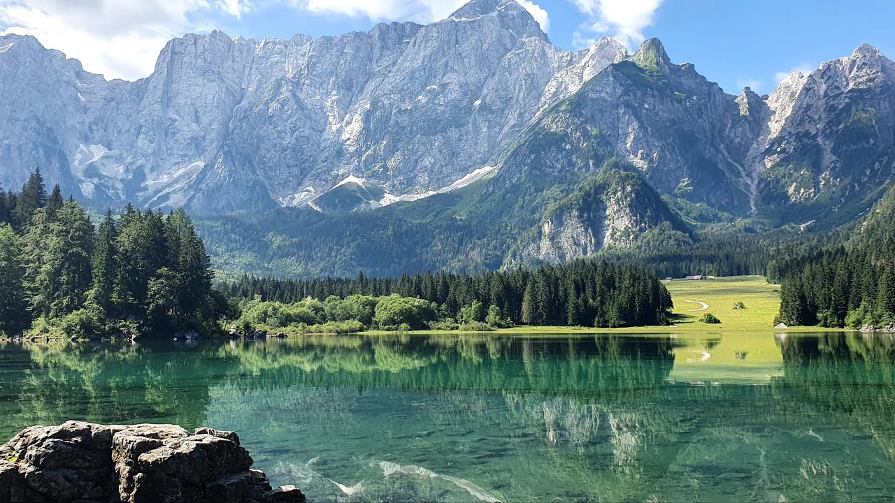
    The Belopeška Lakes have several names. Mangart lakes, Fusine lakes, Klanško lakes, Laghi di Fusine in Italian, Weissenfelser Seen in German, and Lâts di Fusinis in Friulian. Quite a lot of names, no? The Belopeška Lakes consist of two large lakes (Klanško and Mangart lake) located in the Mangart valley near the village of Trbiž, not far from Rateče and the triple border between Italy, Austria, and Slovenia. The Slovenian name derives from the place name Bela Peč. The area of the two glacial lakes was declared the Belopeška Lakes National Park by the Italians in 1971. They are bounded to the south by Mount Mangart and to the east by Ponce Mountains. The upper lake, with a depth of 10 m, lies at an altitude of 929 m, and the lower lake at 924 m.

    If you want to take a beautiful family photo, you should visit not only Lake Jasna but also the Belopeška Lakes in neighboring Italy.

    The trail to the Belopeška Lakes is a bit longer but not too demanding and is ideal for longer family trips. From the Reset Apartments, turn left and follow the cycle path, which initially runs along the northern edge of the Triglav National Park, just below the Vitranc ski slopes. It takes you directly to the border with Italy, so don’t forget your ID cards. At the turn-off for Rateče, there is a small swamp that turns into a beautiful lake during heavy rains in spring and autumn. In winter, of course, if the water level is favorable, the lake turns into a beautiful ice-skating rink in nature.

    We recommend that you take time for a short stop to visit the Zelenci Nature Reserve or take a drive through the idyllic Alpine village of Podkoren. Before turning off towards Planica, you can take a detour through Rateče, where you can experience an adventure in the Escape Museum or stop at one of the many taverns and restaurants that are known far and wide for their exceptional offer of homemade food and drinks. You can also stop at the Pehta log cabin, located under the Podkoren part of the ski resort, just before the turnoff for the Zelenci Nature Reserve. Here you can always try ’spoon dishes’.

    Crossing the border is easy, as you are only reminded that you are already in neighboring Italy by a sign indicating that you are crossing the national border. Shortly after crossing the border, look out for the signpost – straight ahead for Tarvisio, left for Lago di Fusine. Turn left along the path through the meadows into the woods and follow it all the way to the main road, which takes you directly to the lakes. If you miss the turn-off, continue all the way to the main road, where you turn left towards the lakes, but be aware that this is a longer route and quite busy.

    If you drive to the lakes, you will have to pay an entrance/parking fee. If you want to refresh yourself with a cold drink or an ice-cream, there is a lodge at the lower lake with a terrace and an extraordinary view of the mountains surrounding the lake.

    View of the surrounding mountains

    • Visoka Ponca (2.274 m)
    • Kotova špica (2.376 m)
    • Jalovec (2.645 m)
    • Mangart (2.679 m)
    • Mangartsko sedlo (2.055 m)
    Video

    YouTube player

    Planica – Tamar Valley

    Planica – Tamar Valley

    Leave the road, take the trails

    Planica and Tamar Valley

    Lake Jasna
    Reset Apartments
    ^
    Podkoren
    ^
    Zelenci Nature Reserve
    ^
    Planica
    Tamar Valley
    Planica: Easy
    Tamar: Medium
    !
    Elevation: 811 m - 1.109 m
    Planica: 5.4 km
    Tamar: +3.7 km
    *
    298 m of elevation
    Asphalt - Forest
    Macadam road

    MUST VISIT

    Zelenci Nature Reserve
    Nadiza spring
    Tamar Lodge

    WHERE TO NEXT?

    From Planica to Belopeska jezera
    From Rateče to Tromeja (Triple Border)
    Kranjska Gora, Slovenia

    The route is suitable for mountain bikers!

    The Tamar Valley is one of the most beautiful glacial valleys in the Triglav National Park and is extremely popular with hikers, mountain bikers, and cross-country skiers. It is bordered by the mighty walls of the mountains Visoka Ponca (2,228m), Kotova Špica (2,376m), Jalovec (2,645m)… There is also the source of the Nadiža River, which sinks into the gravel at the foot and reappears in the Zelenci Nature Reserve. It also serves as a starting point for hikes and ascents of the surrounding mountains. The path is macadam and well maintained, suitable for children.

    Tamar chapel and the Tamar Lodge

    The Tamar Valley is a continuation of the world-famous Planica Valley, where world championships in ski jumping, ski flying, and other Nordic disciplines are held. We recommend, among other things, that you visit the museum located in the Planica Nordic Centre.

    How to get there

    From the Reset Apartments, turn left and follow the cycle path towards Podkoren, just below the Vitranc ski slopes. You continue until the end of the ski slopes, where the Pehta log cabin is located. Here you can always try spoon dishes, croissants, or authentic homemade sour milk. If you have time, you can also explore the Zelenci nature reserve, which is on the opposite side of the cycling route.

    Continue along the cycling route until you reach the regional road, where you turn left towards Planica, but we recommend that at the end of the plain, a few minutes walk from the Pehta log cabin, you turn left onto the forest track, which will take you through the forest directly to Planica. The path through the forest is also much shorter and more interesting, especially for children.

    If you have younger children or you are not in the best shape, we recommend that you finish the trip with a visit to the Planica Nordic Centre and the ski jumps and then return. Alternatively, you can drive and start your journey to Tamar only in Planica.

    At the end of Planica, you have two options. You can continue along the wide, macadam track (left) or head through the forest (right) on a track that is intended for cross-country skiers in winter and is popular with mountain bikers in summer. Both trails take you all the way to the end of the Tamar valley, directly below the mighty walls of the Jalovec mountain. Here you will find the Tamar lodge, one of the most popular excursion spots in the entire area. The lodge is open all year round and offers visitors the chance to rest and enjoy good local food and drink.

    Activities

    The road to Tamar is a full-day trip, especially if you take in all the sights along the way. It’s quite a long walk, so plan at least a lunch stop. On the way, you can explore the Zelenci Nature Reserve, see the ski jumps, and zipline down the Planica Giant (you have to pre-book online for the zipline). You can also try free-falling in the wind tunnel or play a round of Disc golf on the greens below the ski jumps. We also recommend visiting the Ski Jumping Museum, located in the Planica Nordic Centre.

    Nearby walking paths

    • At Rateče, instead of heading towards Planica, you can continue towards Belopeška Jezera
    • Turn into the village of Rateče and climb to the Triple Border
    • Climb from Planica to the top of Ciprnik

    Attractions

    • Planica Nordic Centre
    • Lodge in Tamar

    Attractions nearby

    • Village linden tree in Podkoren
    • Zelenci Nature Reserve
    • Escape Museum – Kajžnik’s House in Rateče
    • The source of the river Nadiža

    View of the mountains in the surroundings

    • Visoka Ponca (2.228m)
    • Kotova špica (2.376)
    • Jalovec (2.645 m)
    • Travnik (2.379 m)
    • Visoka Peč (1.749 m)
    Video

    YouTube player

    Krnica Valley

    Krnica Valley

    Leave the road, take the trails

    Krnica Valley

    Lake Jasna
    Reset Apartments
    ^
    Kranjska Gora
    ^
    Jasna Lakes
    Krnica Valley
    Easy
    !
    Elevation: 811 m - 1.119 m
    7.9 km
    *
    308 m of elevation
    1 h 50 min walk
    Asphalt - Macadam

    MUST VISIT

    Jasna Lakes
    Krnica Lodge

    WHERE TO NEXT?

    Tour under Kriška wall
    Vrsic mountain pass
    Kranjska Gora, Slovenia

    The route is suitable for mountain bikers!

    The Krnica Valley Trail is one of the most popular hiking destinations in Kranjska Gora, as it is relatively gentle and easy. The valley belongs to the Triglav National Park and is surrounded by many peaks of the Julian Alps, which offer magnificent views of the mighty walls and peaks of Škrlatica, Prisank, Razor… These surround the valley from almost all sides. The valley is also one of the starting points for hikes in the surrounding mountains, and in winter it is a paradise for ski touring skiers.

    The Krnica hut is almost completely covered with a blanket of newly fallen snow.

    You will have to overcome a little more than 300 m of elevation gain to reach the Krnica lodge, but you will hardly notice it because the trail is evenly sloped from start to finish. Due to its popularity among hikers, the valley is quite busy at weekends, so you should go during the week.

    How to get there

    From the Reset Apartments, turn left along the cycle path back to Kranjska Gora. In the center, turn right to continue to the Best Western Hotel, where you turn right onto Vršiška cesta (‘Vršiška road’). In just a few minutes you will arrive at the first obligatory stop – Lake Jasna. You can cross the road on the macadam path that runs between the right bank of both lakes and the Pišnica River. Continue to the bridge over the river, where the macadam trail to Krnica branches off to the left. There is also a sign indicating whether the Krnica lodge is open.

    The macadam trail along the Pišnica river is well-maintained and properly signposted. The last part of the trail leads through the forest and takes you to the Krnica lodge, which is open every day during the tourist season and at least at weekends during the off-season. Here you will be able to refresh yourself with local delicacies and ‘spoon meals’, and we recommend the lodge as the final destination of your hike.

    If you like cycling, you can also go mountain biking.

      Activities

      The banks of the Pišnica river are famous for their snow-white gravel and are very interesting for younger children with their many small dead channels. Here you can have a family picnic while the children can explore nature and play by the water.

      If the path to the lodge is too short for you, you can continue to the walls of Križ, which close off the valley path, or you can choose one of the many mountain hikes that lead to the peaks of the surrounding mountains.

      View of the surrounding mountains:

      • Rušica (2.096 m)
      • Špik (2472 m)
      • Škrlatica (2.740 m)
      • Stenar (2.501 m)
      • Dolkova špica (2.591 m)
      • Križ (2.140m)
      • Kriški podi (2.050 m)
      • Razor (2.601 m)
      • Prisank (2.547 m)
      • Goličica (2.101 m)
      Video

      YouTube player

      Pericnik Waterfalls

      Pericnik Waterfalls

      LEAVE THE ROAD, TAKE THE TRAILS

      Pericnik Waterfalls

      Reset Apartments
      ^
      Mojstrana
      Vrata Valley
      Pericnik Waterfall
      Medium
      Must see
      !
      Elevation: 647 m - 771 m
      19.2 km
      4.7 km from Mojstrana
      *
      Height difference: 124 m
      19.6 km
      300 m forest walk

      MUST VISIT

      Slovenian Alpine Museum in Mojstrana
      Jakob Aljaz Lodge

      WHERE TO NEXT?

      Uper Vrata Valley
      Kranjska Gora, Slovenia

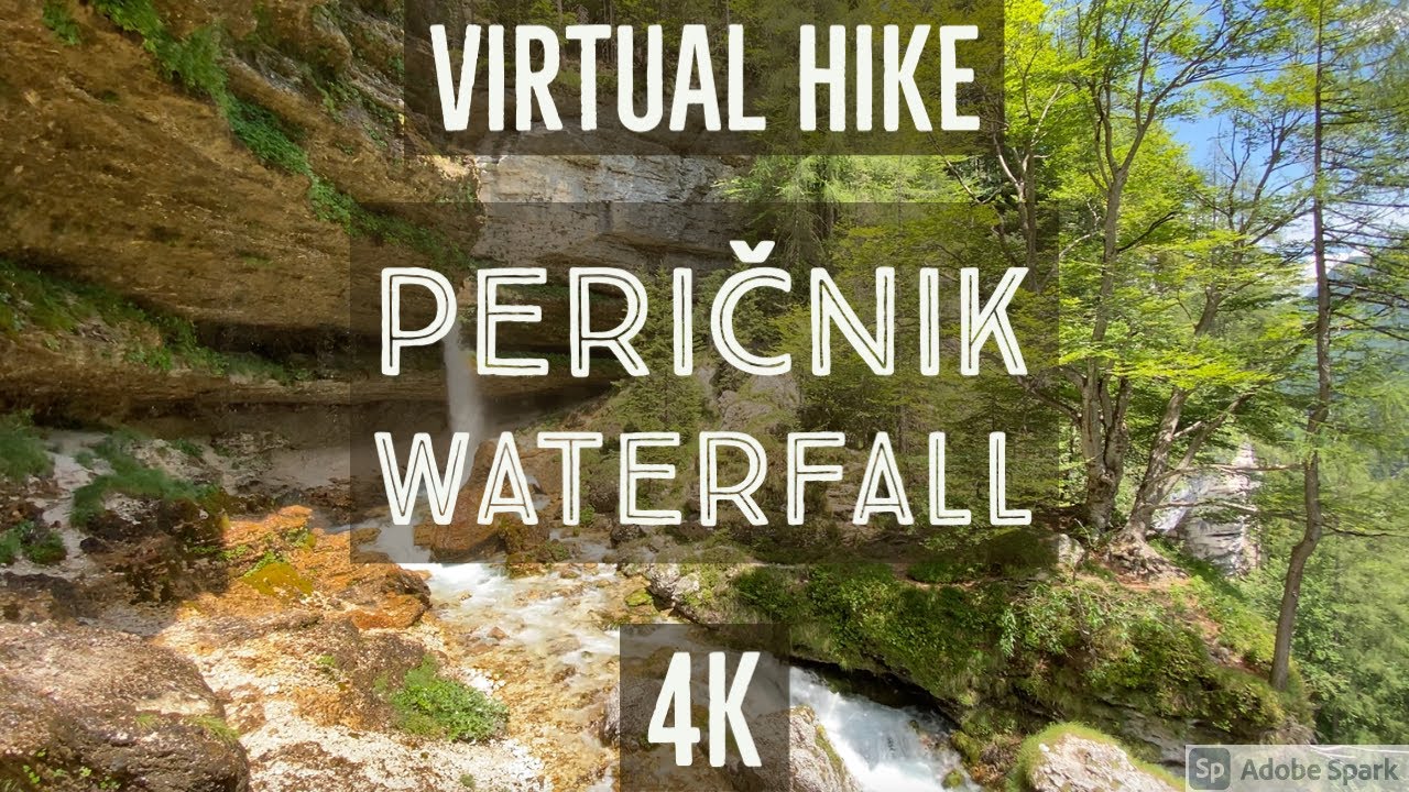
      A protected natural heritage Pericnik Falls is one of Slovenia’s highest and best-known waterfalls. Both of the waterfalls are free to visit, have easy access and offer stunning scenery. You can even walk behind one of the waterfalls so, if you are looking for a great family photo this is the right place for you. The falls are located in the glacial Vrata Valley in Triglav National Park, where the water of Pericnik Creek flows into Bistrica Creek. The upper Pericnik Fall is 16 m high and the lower is 52 m. Must see 🙂

      A view from behind the waterfall.

      Getting to the waterfalls

      The waterfalls can be visited in both summer and winter. It is most attractive in autumn or spring when the water level is higher, and in winter, when temperatures drop below zero for longer periods and the waterfalls transform into a beautiful curtain of ice candles and sculptures.

      We recommend that you go directly to the waterfalls by car or at least drive to the village of Mojstrana, from where you can continue on foot through the glacial valley of Vrata. From the apartments, you can also cycle along the cycling route to Mojstrana (described in the Mojstrana article), from where you will have a slightly more difficult climb directly to the waterfalls themselves. In the summer months, there is also a tourist bus from Kranjska Gora to the waterfalls (click here for the timetable).

      In any case, the route to the waterfalls starts in the village of Mojstrana, from where you follow the road through the glacial valley of Vrata all the way to the car park and the lodge at the Peričnik waterfall. Whether you set off by bike, car, or bus, you will have to continue on foot from here. The forest path is well maintained and fortunately not long. It runs along the right bank of the Peričnik River (on the right side if you are looking from the direction of the car park) and after about 10 minutes it leads to the first viewpoint at the lower waterfall, which you can see from all sides as the path leads directly from the waterfall.

      If you want to see the upper waterfall, you will have to go back along the same path a few tens of meters to the Peričnik – upper waterfall marker, where the path starts to climb steeply all the way to the viewpoint at the upper waterfall.

      Attractions in the surroundings

      If you are already in this area, it would be a pity not to continue all the way to the end of the Vrata valley, where the well-known Aljažev dom (Aljaž Lodge) stands at 1015m, with a wonderful view of the northern face of Slovenia’s largest mountain, Triglav. You can also see a giant wedge with a carabiner, a memorial to all the victims who were taken by the mountains.

      On the way back, we suggest you visit the Slovenian Alpine Museum in Mojstrana. For more information about the museum, click here.

      Vrata Valley is a starting point for excursions and hikes in the mountains

      Vrata Valley is one of the best-known starting points for mountaineering tours to many of the surrounding mountains.

      Easy routes:

      • Zgornje Kriško jezero – Upper Lake Kriško (past Pogačnikov dom – Pogačnik Lodge
      • Koča na Doliču
      • Kanjavec
      • Luknja
      • Bivak na Rušju (a bivouac)
      • Bivak pod Luknjo (a bivouac)
      • Gubno
      • Kucelj (Julian Alps)

      Moderately difficult routes:

      • Pogačnikov dom na Kriških podih (via Sovatno)
      • Spodnji Stenar (over Sovatno)
      • Križ (past the bivouac at Rušje)
      • Kriški rob (over Sovatno and past Pogačnikov dom)
      • Šplevta (Indijanec)

      Difficult mountain hikes::

      • Triglavski dom na Kredarici (over Prag)
      • Bovški Gamsovec (over Luknja)
      • Bovški Gamsovec (via Sovatno)
      • Stenar (over Sovatno)
      • Stenar (over Stenarska vratca)
      • Dolkova špica (western route)
      • Križ (over Sovatno)
      • Rjavina (over Prag)
      • Cmir (over Prag)
      • Begunjski vrh (over Prag)
      • (Tominškova pot)
      • (over Prag)
      • Visoka Vrbanova špica (over Prag)
      • Planja (over Sovatno)
      • Šmarjetna glava (past Koča na Doliču)

      Caution! Extremely difficult hikes:

      • Triglav (Tominškova pot)
      • Triglav (via Plemenice)
      • Triglav (Gamsja cesta round Triglav)
      • Razor (via Sovatno)
      • Dolkova špica (eastern route)
      • Dolkova špica (along the south-east ridge)
      • Križ (over Stenarska vrata)
      • Cmir (Tominškova pot)
      • Rjavina (Tominškova pot)
      • Rogljica (western route)
      • Begunjski vrh (Tominškova pot)
      • Glava v Zaplanji (over Plemenice)

      Mountaineering ascents:

      • Spodnji (Lower) Rokav (Potočnik – Tominšek)

      View of the surrounding mountains:

      • Triglav (2.864 m)
      • Stenar (2.501 m)
      • Begunjski vrh (2.461 m)
      • Sleme (1.656 m)
      • Kukova špica (2.417 m)
      • Dolkova špica (2.591 m)
      • Dovški Križ  (2.542 m)
      • Škrlatica (2.740 m)
      • Razor (2.601 m)
      • Križ (2.140 m)
      • Bovški Gamsovec (2.392 m)
      Video

      YouTube player